• Member Login
  • |
  • Join Now
PESA - Energy Geoscience

Promoting Professional and Technical Excellence in Energy Geoscience – Networking, On-going Professional Education, Monthly Technical Meetings

  • Home
  • About
    • About PESA
    • Objectives
    • PESA History
    • PESA Affiliates
    • Constitution and Rules
    • Strategic Plan
  • Events
    • Online
    • NSW / ACT
    • QLD
    • SA / NT
    • VIC / TAS
    • WA
    • Industry
    • Social
    • Past Events
  • Membership
    • Join Us
    • APPEA Conference Discounts
    • AEGC 2025 Travel Bursaries
    • PESA Membership Awards
  • Latest News
    • All News
    • Feature Articles
    • Industry
    • Company Updates
    • Tech Talk (public)
    • PESA Branch Activities
  • Library
    • Technical Library
    • PESA Gazette
    • Webinars
    • PESA News Magazine
    • Knowledgette Recordings
  • Scholarships
  • Employment
    • View Job Opportunities
    • Submit Job
  • Contact
Feature Articles
Industry
Seismic (public)

WA onshore release areas for petroleum exploration

Posted by Dale | 07/08/2017

07/08/2017 by Dale

share
share
tweet

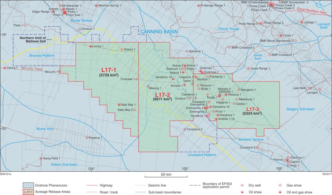
The Department of Mines, Industry Regulation and Safety (DMIRS) continues to promote the petroleum potential of Western Australia’s vast sedimentary basins using a specific area release system. On 16 May 2017, DMIRS gazetted a total of five onshore release areas in the central and southern Canning Basin (Fig.1). Release area size ranges from 5324 km2 to 6667 km2. This gazettal was timed to coincide with the 2017 APPEA Conference in Pert, reports Richard Bruce, DMIRS exploration geologist Petroleum Division.

Canning Basin

Interest in the Canning Basin has revived significantly in recent years with new oil plays discovered at Ungani 1 and Ungani Far West 1. Canning Basin oil may be trucked to ports in the north of the State for shipment to refineries in southeast Asia or trucked to the Kwinana oil refinery in the south of the State.

The northern three Release Areas, L17-1 to -3, are contiguous and collectively cover 17,664 km2 (Fig. 2). These areas are accessible from Broome via the Great Northern Highway and extend from the southeastern Broome Platform eastward, across the northwestern Crossland Platform and the central Barbwire Terrace, and into the Gregory Sub-Basin. These are among the best explored regions of the Canning Basin, where 15 wells have recorded hydrocarbon shows, including Looma 1, Acacia 2, Mirbelia 1 and 2 and Sally May 1.

Release Areas L17-1 to -3 are considered prospective for both subsalt (Ordovician) and suprasalt (Devonian) plays. A new Devonian play has been proposed for the Barbwire Terrace, where a series of en echelon wrench-related anticlines have been interpreted from seismic data.

The southern two Release Areas, L17-4 and L17-5, collectively cover 12,905 km2 and are regarded as frontier acreage, with much less on-ground exploration than the northern three Release Areas (Fig. 3). However, couldn’t there be room for a large discovery? Salt diapirism may provide traps in areas of the basin that lack major block faulting.

‘The best remaining frontier prospects lie … in older basins with a high preservation potential such as intracratonic basins with evaporite seals.’

Duncan S Macgregor, BP, 1996

Release Areas L17-4 and L17-5 are contiguous and lie just south of the three northern Release Areas. These two Release Areas are accessible via the Kidson Track, the Kiwirrkurra  Road and the Canning Stock Route and extend across the northern flank of the Kidson Sub-basin eastward, over the southwestern flank of the Crossland Platform. The closest well to the southern Release Areas is Gibb-Maitland 1, drilled during December 2012. Peripheral margins of the Kidson Sub-basin are generally considered prospective for conventional salt-related plays (including sub-salt Ordovician) that have hardly been tested.

Release information

This information includes prospectivity of release areas, a Canning Basin summary, available data listings, new bid assessment guidelines, land access and environment considerations, schedule of fees and information regarding how to make a valid application for an exploration permit. More detail on the prospectivity of the Release Areas has been described by the Geological Survey of Western Australia.

The most current release information is available on the Department’s website at:   www.dmp.wa.gov.au/acreage_release

Work program bids for the release areas close at 4pm Australian Western Standard Time on Thursday 1 February 2018 and applications can only be made online.


Related Articles

Dr Graeme Bethune
‘Gas and Oil exploration renaissance finally underway’

25/06/2019

Seven Australian exploration permit awards target $530 million

06/11/2018

Drone attacks put petrochemical feedstock supply under strain

24/09/2019

WA Onshore Acreage Release

22/09/2016

Show CommentsHide Comments

Become a Member

petroleum exploration society member badge

Join PESA now and enjoy full membership benefits

  • access to fully searchable technical library
  • extensive networking opportunities with industry leaders and peers
  • further professional education and training
  • and more!

VISIT MEMBERSHIP PAGE

View Upcoming Events By Branch

PESA Events by State PESA Events in Western Australia PESA Events in South Australia and Northern Territory PESA Events in Victoria and Tasmania PESA Events in NSW PESA Events in Queensland

(Click on the the map)

Sponsored

PESA MAGAZINE – LATEST EDITION

PESA News Issue 173

Previous Editions

POPULAR POSTS

  • Shell Discovery Map WA Shell makes ‘significant’ gas discovery offshore Australia
  • APPEA CEO Samantha McCulloch Meet Samantha McCulloch, APPEA’s new CEO
  • USA oil exports exceeded imports 2019 How the USA became the world’s largest crude oil exporter in 2019
  • PESA WA Winter warmer at the Museum
  • SA announces successful applicants for acreage in Cooper and Otway Basins
  • CUE Permits NWS Ironbark exploration well delivers a disappointing duster

Norwood Resources

the Norwood resource

PESA members please use this group to help with "social license to operate" issues.

TOPICS

AEP Annual General Meeting Archer AVO AVO inversion Barry Goldstein Award Bowen inversion Branch News Bruce Ainsworth climate change complex seismic wavefield core workshop Dorado Early Triassic eFWI elastic full waveform inversion Energy Geoscience GA Golf Henry Posamentier Industry News Middle Triassic Mungaroo inversion NWS inversion PESA petroleum cores Qld Queensland CSG Queensland gas SA/NT Scholarships seismic inversion sequence boundary Social Surat-Bown Basin systems tracts WA wave influenced deltas WEB-AVO inversion women in energy women leadership women leadership scholarships womens career development women scholarships Zillmere core store

PESA - Energy Geoscience

PESA Energy Geoscience is a non-profit association of individuals involved in the exploration of oil and gas.

Connect with us

Subscribe to our newsletter and stay on the loop of what is happening in the field of Energy Geoscience and events near you.

pesa newsletter
* indicates required

PESA Energy Geoscience will use the information you provide on this form to be in touch with you and to provide updates and marketing. Please confirm you give us permission to contact you via your email address:

You can change your mind at any time by clicking the unsubscribe link in the footer of any email you receive from us. We will treat your information with respect. For more information about our privacy practices please visit our website. By clicking below, you agree that we may process your information in accordance with these terms.

We use Mailchimp as our marketing platform. By clicking below to subscribe, you acknowledge that your information will be transferred to Mailchimp for processing. Learn more about Mailchimp's privacy practices.

Copyright © 2025 PESA - Energy Geoscience. All Rights Reserved.

  • Advertise
  • Contact
  • Policies
  • Privacy
  • Terms & Conditions