WESTERN AUSTRALIAN ONSHORE ACREAGE RELEASE SEPTEMBER 2016
Richard Bruce, Exploration Geologist Petroleum Division
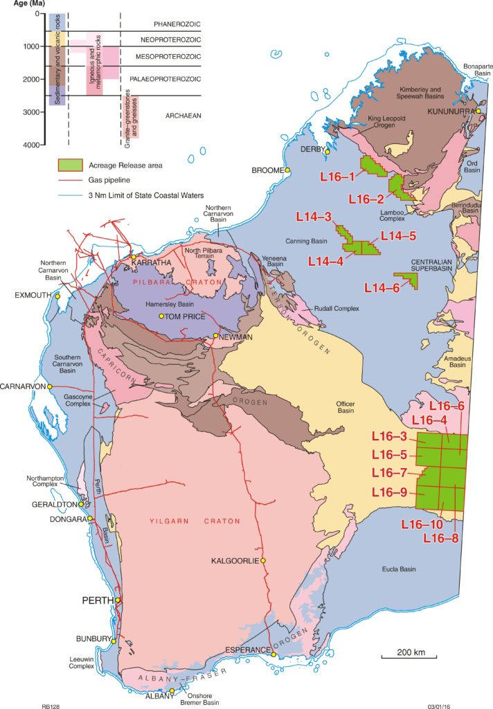
The Department of Mines and Petroleum (DMP) continues to provide access to the petroleum potential of Western Australia’s vast sedimentary basins using a specific area release system. On 13 September 2016 DMP released a total of fourteen onshore areas or blocks (see related image). This release comprises six blocks in the Canning Basin and eight blocks in the Officer Basin.
Release information
This information includes prospectivity of release areas and of relevant basins, available data listings, new bid assessment guidelines, land access and environment considerations, schedule of fees and how to make a valid application for an Exploration Permit.
Release information will be available on USBs for distribution at events and meetings. The most current information will be available on the Department’s website: www.dmp.wa.gov.au/acreage_release
Work program bids for the release areas close 4 pm Australian Western Standard Time on Thursday 9 March 2017. As applications can now only be made online, it is recommended to register at least two business days before bids close.
Canning Basin
Interest in the Canning Basin has revived significantly in recent years, with new play oil discoveries at Ungani 1 and Ungani Far West 1, and large estimates for shale gas. Canning Basin oil may be trucked to ports in the north of the State for shipment to refineries in southeast Asia or trucked to the Kwinana oil refinery in the south of the State.
There are two release areas on the Lennard Shelf and four release areas in platform areas (Broome and Crossland Platforms), with one area partly in the Kidson Sub-basin. Area size ranges from 1769 km2 to 4392 km2.
The platform release areas (L14-3 to L14-6) became available for gazettal by statutory relinquishment at the end of permit terms from Buru Energy Exploration Permits. These release areas may be prospective for multiple sub-salt Ordovician plays. Such plays include Nita Formation dolomitic or fractured carbonates, Upper Willara Formation cavernous carbonates, Acacia Sandstone Member and Nambeet Formation sandstones. Mature source intervals may either intergrade with or lie adjacent to reservoirs, and thick salt or shale layers are less likely to leak or be damaged by faults and fractures. Minimal post-Devonian movement has taken place to damage seals. Structural traps may include anticlines, fault blocks and salt-related traps. Stratigraphic traps may include facies or thickness variation and unconformity-related traps. Hydrocarbon shows in Sally May 1 and 2 may indicate that oil and gas has migrated into the release areas.
The central Canning Basin is covered by a uniform grid of aeromagnetic and ground gravity data, available for download from the Australian geoscience portal www.geoscience.gov.au. Data processing and modelling may prove useful for planning infill seismic lines.
Release areas L16-1 and L16-2 are situated on the Lennard Shelf. The areas are traversed by the sealed Great Northern Highway and lie close to production facilities of the Blina oilfield. Lennard Shelf fields have had commercial oil production from Devonian carbonates and Permian-Carboniferous sandstones. A gas show was encountered in the Chestnut 1 well in release area L16-1.
The prospectivity of the Carboniferous Laurel shale play is considered to be high in L16-1, which is adjacent to the Valhalla–Paradise gas accumulation. The Devonian Gogo and Virgin Hills Formations in inter-reefal channels and fault troughs may be another shale and/or tight gas play within both release areas.
Conventional plays include basinal fan systems and turbidites of the Devonian reef complexes, and associated platform facies. Platform facies may offer the best potential traps. Both structural and stratigraphic traps are expected in platform facies due to horizontal and vertical permeability barriers, faulting and erosional sequence boundaries. Pillara and Nullara reefs and platforms are fairly well imaged in L16-2. Stratigraphic traps are likely in back-reef subfacies, such as lagoonal and intertidal sequences. Stratigraphic traps are also expected in interfingering, mixed clastics and carbonates on marginal-slopes and basin floors, including fan systems and turbiditic sequences.
Release areas L16-1 and L16-2 are partially covered by fair- to good-quality seismic data and have well control. Potential field data and numerous mineral exploration drillhole data are also available.
Officer Basin
The Officer Basin resembles Neoproterozoic successions in Oman and Russia that contain giant oil- and gasfields. Numerous oil shows have been encountered in Western Australian and South Australian mineral, petroleum and stratigraphic drillholes. Gas shows have also been encountered (for example, Vines 1 in L16-4 and Birksgate 1 to the east of the release areas). It appears that all the elements of a petroleum system are present in the basin. Good source beds and proven reservoirs capped by thick sections of salt or shale have been intersected. There may be sub-salt and unconventional hydrocarbons present.
There are eight large release areas (L16-3 to L16-10) in the central Officer Basin adjacent to the South Australian border. These release areas range in size from 5054 km2 to 8129 km2. These are frontier areas but there were indications of petroleum migration in Vines 1.
As salt-tectonics has deeply and more widely affected the northern portion of the western Officer Basin, in addition to structural and stratigraphic traps, there is a possibility of salt-related plays, particularly in the northern release areas (L16-3 to L16-6). If salt has been remobilised during younger tectonic events, secondary migration to shallower traps may have taken place.
In the southern release areas (L16-7 to L16-10), Mabel Creek seismic data indicates that broad, gentle folds are present. Gravity data also indicate that basement highs are present. The basement highs may have been draped, possibly with four-way closure.
The unsealed Connie Sue and Ann Beadell Highways provide access to the area. Side roads and tracks extend into the release areas. The Trans-Australian Railway passes about 200 km to the south. The Goldfields Natural Gas Transmission Pipeline lies about 300 km west of the basin.